District-Level Tourism Density, Development & Capacity (DTC) - Methodology
Data Collection
Fieldwork observation
Data for the two variables below are collected through fieldwork observation. In order to collect data for people flow per hour and visitor to resident ratio, fieldwork observers use simple manual clickers along a particular street at a designated sampling location (please refer to sampling locations below) in the pilot study.
(a) People Flow/Hour
Cumulative people counts are collected in 2 hours interval in each sampling location on any planned survey day. Averaging the two hours cumulative people counts give the people flow per hour.
(b) Visitor:Resident Ratio
Visitor and resident counts are collected in every 3 minutes interval in each sampling location on any planned survey day. Sum of visitor counts divided by sum of resident counts give the visitor to resident ratio.
Fieldwork survey
Data for the variable below is collected through fieldwork survey, respondents are selected following a systematic random sampling technique and interviews are conducted face-to-face with a structured questionnaire. Interviews are conducted in either English or Chinese. Permanent or non-permanent resident in Macao are the targeted respondent. Respondents are asked about what do they think about their living neighborhood in terms of level of tourism, potential and supportiveness, and are also asked to give comment or suggestion for development and improvement.
(c) Level of Tourism, Potential and Supportiveness
Summation of the following 3 scoring questions which based on a continuous scale from 0 to 5 (0 is the lowest, 5 is the highest), maximum score is 15.
From your daily experience and observation on a typical day, what is the level of tourist visit the street where you live? (reversed coded)
Considering the street where you live, how much potential do you think there is to develop it further for tourism purposes?
How much would you personally support the further development of the street where you live for tourism purposes?
Sampling Locations
The map of Macao peninsula is divided into 59 grids. Each grid consists of one sampling locations. The sampling location map for each living grid can be viewed here.
Heat Map
Heat map is chosen for data visualization as this metric is able to track the traffic count and other key variables. It shows the intensity level through the use of gradient colors, with darker colors showing higher intensity.
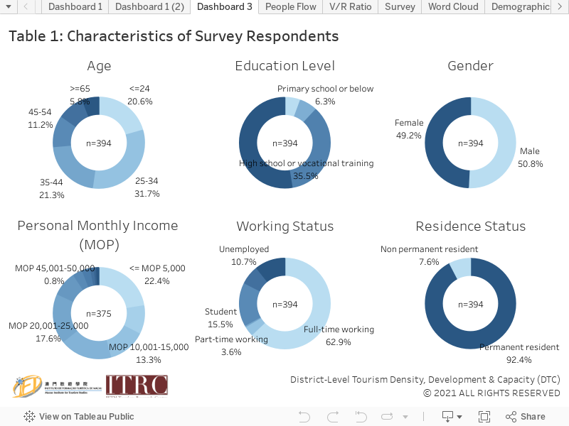
Characteristics of Survey Respondents
Characteristics of survey respondents for data collected in 2020 Quarter 4 are reported in Table 1 below. All analyses in this project are based on unweighted samples.